


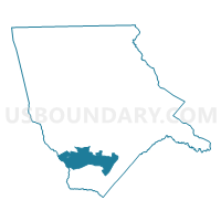
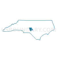
Voting District WAB, Moore County, North Carolina
About
Outline

Summary
| Unique Area Identifier | 640925 |
| Name | Voting District WAB |
| County | Moore County |
| State | North Carolina |
| Area (square miles) | 28.66 |
| Land Area (square miles) | 28.58 |
| Water Area (square miles) | 0.08 |
| % of Land Area | 99.72 |
| % of Water Area | 0.28 |
| Latitude of the Internal Point | 35.14513680 |
| Longtitude of the Internal Point | -79.51416860 |
Maps

Graphs
Select a template below for downloading or customizing gragh for Voting District WAB, Moore County, North Carolina


Neighbors
Neighoring Voting District (by Name) Neighboring Voting District on the Map
- Voting District 10, Richmond County, NC
- Voting District EAB, Moore County, NC
- Voting District PBF, Moore County, NC
- Voting District PDN, Moore County, NC
- Voting District PHA, Moore County, NC
- Voting District PHB2, Moore County, NC
- Voting District PHC, Moore County, NC
- Voting District SSP, Moore County, NC
- Voting District WND, Moore County, NC
Top 10 Neighboring County Subdivision (by Population) Neighboring County Subdivision on the Map
- Township 9, Mineral Springs, Moore County, NC (25,915)
- Township 8, Sandhills, Moore County, NC (17,032)
- Beaverdam township, Richmond County, NC (3,676)
Top 10 Neighboring Place (by Population) Neighboring Place on the Map
- Pinehurst village, NC (13,124)
- Southern Pines town, NC (12,334)
- Aberdeen town, NC (6,350)
- Pinebluff town, NC (1,337)
- Foxfire village, NC (902)
Top 10 Neighboring Unified School District (by Population) Neighboring Unified School District on the Map
Top 10 Neighboring State Legislative District Lower Chamber (by Population) Neighboring State Legislative District Lower Chamber on the Map
Top 10 Neighboring State Legislative District Upper Chamber (by Population) Neighboring State Legislative District Upper Chamber on the Map
Top 10 Neighboring 111th Congressional District (by Population) Neighboring 111th Congressional District on the Map
Top 10 Neighboring Census Tract (by Population) Neighboring Census Tract on the Map
- Census Tract 9511, Moore County, NC (8,172)
- Census Tract 9503.02, Moore County, NC (4,837)
- Census Tract 9507.01, Moore County, NC (4,542)
- Census Tract 9512, Moore County, NC (4,364)
- Census Tract 9701, Richmond County, NC (3,676)
- Census Tract 9506.01, Moore County, NC (3,259)
- Census Tract 9507.02, Moore County, NC (2,588)
Top 10 Neighboring 5-Digit ZIP Code Tabulation Area (by Population) Neighboring 5-Digit ZIP Code Tabulation Area on the Map
- 28374, NC (15,990)
- 28387, NC (13,921)
- 28315, NC (11,681)
- 27376, NC (9,386)
- 28338, NC (4,607)
- 27281, NC (3,100)
- 28373, NC (2,150)